If the coming storm hits as predicted starting late Thursday, San Joaquin Valley flooding hot spots – and some new ones thanks to subsidence – could be swamped.
It’s not because reservoirs above the valley floor are full. The culprits are likely to be much the smaller and typically dry “uncontrolled streams” threaded throughout the foothills.
Immediate uneasiness
The “biggest and most immediate uneasiness” are foothill creeks, the Kings River Water Association wrote in an alert put out on Tuesday about anticipated flooding.
Pine Flat Reservoir and other upstream reservoirs, including Wishon and Courtright, have more than 600,000 acre-feet of available space and can handle surges from the upper Sierra Nevada.
“Mill Creek and the other foothill streams that enter the river downstream from Pine Flat Dam are our biggest concern right now,” Steve Haugen, executive director of the Kings River Water Association wrote in the alert. “There is no way to control or store the flows in those streams.”

Normally, just a trickle, Mill Creek could swell up to between 4,500 and 14,600 cubic feet per second, according to the alert. Think of a cubic foot as the size of a basketball, with up to 14,600 going by a stationary point every second.
The Sheriffs and emergency services departments for Fresno, Kings and Tulare counties are all on watch and the Kings River Conservation District, responsible for flood protection on the forks of the lower Kings River, has been checking its levees, according to the alert.
A new lake bottom
In southern Kings County, all eyes are on Deer Creek and the White River, according to Jack Mitchell, head of the Deer Creek Flood Control District.
“We have equipment on call and are just waiting to see,” Mitchell said. “I think this is gonna be a 100-year flood with how much snow there is. If this storm melts it up to 8,000 feet, we’re gonna get hit.”
The small town of Alpaugh should be OK, he said. Land to the north and east, however, could be flooded for the first time thanks to groundwater overpumping that has sunk the land, he added.

“It’s gonna be hell for the people up there,” Mitchell said. “They’re in a hole and they don’t know it.”
Historically, Deer Creek and White River followed gravity into the old Tulare Lake bed. That water has to be pumped into the lakebed now because the land around Angiola along Highway 43 has sunk 24 feet, according to a recent elevation survey conducted for the Deer Creek district, Mitchell said.
“That’s the new lake bottom.”
New flood zones
In fact, a 2017 engineering study for California High Speed Rail, which runs along 43, said the topography east of Corcoran had changed so much because of groundwater pumping that entirely new flood zones had been created.
That could be problematic for Corcoran, which has a levee west of town protecting it from flood waters that have historically risen from the old Tulare Lake. There is no levee protecting it from flood waters east of town.
“That’s a theory,” said said Dustin Fuller, head of the Cross Creek Flood Control District. “But the good news is Tulare Lake has to fill up before it affects our levee and we’re a very long way from that.”
In 2017, the district had to rush to rebuild the levee, which had sunk from groundwater overpumping. Pumping on a massive scale has continued to sink the levee, along with Corcoran and the Tulare Lake bed.
On standby
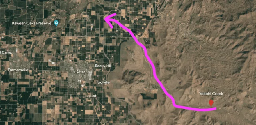
“We are concerned,” said Mark Larsen, the Kaweah River Watermaster. “It looks like this system is going to push the limits. For us, the concern is Dry Creek and Yokohl Creek. If those start rolling, they’ll shut down releases (from Kaweah Lake).”
Kaweah Lake has 185,000 acre feet of storage and is currently only holding 58,000 acre feet, he said.

Larsen said farmers throughout the area have been preparing to take water and spread it over as much ground as possible to prevent flooding and recharge the aquifer.
“We have crews on standby around the clock and pumps positioned to move water,” he said.
Larsen, who is also General Manager of the Greater Kaweah Groundwater Sustainability Agency, acknowledged he was a little excited to finally have water to put back into the aquifer after three punishing years of drought.
Watching the hotspots
In Kern County, Lake Isabella still has nearly 430,000 acre feet of vacant space to fill so the Kern River isn’t a concern.
But melted snow and rain at lower elevations are expected to fill smaller streams, such as Erskine, Poso and Caliente creeks, and cause potentially serious flooding.
The Kern County Fire Department has already begun to gear up and is watching several hotspots including Lamont, which has a very long history of flooding from Caliente Creek.
The department has large equipment on standby and has staffed an extra 50 firefighters just on hand crews. The department is also staffing extra helicopter pilots for possible hoist rescues and putting together urban search and rescue teams, according to spokesman Andrew Freeborn.

Other county departments including Public Works, Roads and Emergency Services, are likewise gearing up, he said.
“We are taking this storm very seriously,” Freeborn said. “We hope we are overpreparing and we hope citizens do the same. If you know your area has issues with flooding, now is the time to take steps to keep yourself safe. You don’t have to wait for us to tell you to evacuate.”
SJV Water is a nonprofit, independent online news publication covering water in the San Joaquin Valley. Lois Henry is the CEO/Editor of SJV Water. She can be reached at lois.henry@sjvwater.org. The website is www.sjvwater.org.


